Map Reading
Before going walking on your own, you should learn to read a map. Most walk leaders will be prepared to help you with this skill. It is worth trying to follow a walk on your map, cross checking with the leader every so often. You should learn what the symbols mean on your map – there will be a key which explains what they mean.
You can imagine a map as a scaled down bird’s-
The following features can be useful to determine your location but you need to be aware that they may have changed:
- Hedges – these may have been removed by the landowner.
- Woodland – this may have been cut down or newly planted. Stumps or young trees will give you a clue if this has happened.
- Power lines – these are unlikely to have changed. Only power lines on pylons are included on OS maps.
- Remote buildings – these may be new builds or demolished
- Contour lines – these will show the height above sea level and can show you which way the ground slopes
- Roads & paths – these are unlikely to change but you can check the definitive maps before setting out to make sure your map is accurate.
Bearings
To take a bearing, you will need a map and compass.
The grid lines on your map point to grid north whilst your compass needle will point to magnetic north. The offset between these will vary depending on where you are in the world. It will also vary with time. The offset will be printed on the key of your map. Near Oxford, the offset of magnetic north is about 3° west of grid north.
If you want to use bearings over any distance then you will need to make allowance for this difference. Near Oxford, not adjusting will give an error of about 100 yards over a mile. The instructions below explain how to make the adjustment but that step can be skipped.
True north is the direction of the north pole. The grid on OS maps is based on true north at the west edge of the SP grid square (about 50km west of Oxford). Because of the curvature of the earth grid north has a greater offset from true north the further east or west you travel from this location.
Walking in a particular direction
If you know your current location on your map, you can take a bearing and use it to walk to an object on your map. If your target is any distance then you should regularly check that you are going in the right direstion.
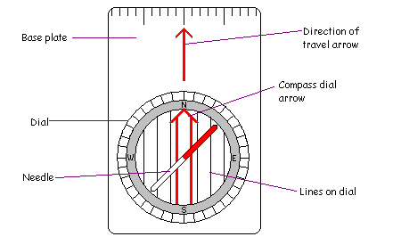
- Place your compass on the map so that the edge passes through your current location and the point which you want to walk to. The arrow on the base plate of the compass should point in the direction you want to travel.
- Turn the compass dial so that the arrow on the dial points to north on the map (the lines on the dial will also be parallel to the north-
south grid lines on the map). You can remove the compass from the map now. - Adjusting for magnetic north offset (optional): If the offset of magnetic north from grid north is west then you need to turn the dial anti-
clockwise by the relevant number of degrees (3 near Oxford). If the offset is east then you would need to turn the dial clockwise. - Turn the compass so that the north pointing needle (normally coloured red) lines up with the arrow on the compass dial. The arrow on the compass base plate will then point in the direction you should walk.
Using bearings to find your location (triangulation)
If you do not know where you are but can see several landmarks, such as a church spire, a pylon or the corner of a wood, you can take bearings on them to work out your location. Repeat the following procedure for at least two landmarks. The more landmarks you are able to use the more certain you can be of your location.
- Line up the arrow on the compass base plate with the landmark. Turn the dial so that the north pointing needle (normally coloured red) lines up with the arrow on the dial.
- Adjusting for magnetic north offset (optional): If the offset of magnetic north from grid north is west then you need to turn the dial clockwise by the relevant number of degrees (3 near Oxford). If the offset is east then you would need to turn the dial anti-
clockwise. - Locate the landmark on your map and place the edge of the compass base plate on it. Keeping the compass fixed on this point, rotate the compass (not the dial) so that the arrow (and the lines) on the dial line up with the north-
south grid lines on the map. - Draw a line along the edge of the compass – you are somewhere along this line.
Once you have drawn two lines, they should cross – this is your location. If you take bearings on more than two points, all the bearings should cross at roughly the same point.