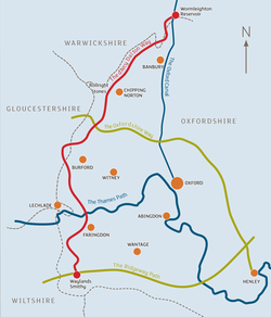
 The d’Arcy Dalton Way was created in 1986 to celebrate the Society’s diamond jubilee. It was named after Colonel d’Arcy Dalton – one of the founding members of the Society. The idea behind the Way was to form a link between the Oxford Canal towpath, the Oxfordshire Way, the Thames Path and the Ridgeway.
The Way’s 65 miles run through the unspoilt countryside along the western side of Oxfordshire. Its northern end is at Wormleighton on the canal towpath. From here it proceeds across the Ironstone Hills, through Hook Norton, passing close to the Rollright stones and then crossing the Oxfordshire Way. The route ducks into Gloucestershire for a few miles before meeting the Thames Path and then dropping down to the Ridgeway, at Waylands Smithy.
The Way can be followed using OS Explorer maps 206, 191, OL45 and 170 or alternatively you can get Nick Moon’s excellent guide book – see the Guide Books links.

